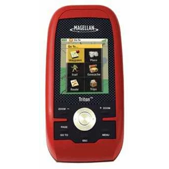
Detail GPS Magellan Triton 500, Magellan GPS Triton 500
GPS Magellan Triton 500, Magellan GPS Triton 500 : Made for the ultimate outdoorsmen the Magellan Triton 500 is loaded with features. Whether you are hunting, hiking, camping, or simply geocaching, the triton 500 will safely guide you along your trip. The high sensitivity WAAS SiRFstar III GPS receiver will keep you on track, even under heavy tree cover. The Triton 500 also features a 3-axis electronic compass for accurate headings even when standing still. The embedded barometer will allow you to track changes in weather and elevation. If you get caught in bad weather, have no fear as the Triton 500 is fully waterproof to IPX-7 standards and has a rugged outer casing for ultimate protection.
The Triton 500 is also compatible with National Geographic TOPO! maps. With an SD card storage slot, you can hold a large area of National Geographic maps on an optional SD card and once the card is plugged into the GPS that detail will show on the Triton’ s display. National Geographic Topo! State Series Maps are the first software to offer 1: 24, 000 scale mapping for the entire US that can be downloaded into a handheld GPS. These maps are downloadable onto the Magellan Triton Series handheld GPS where you can view your location on the crisp 24k USGS maps in real time. This software will also allow you to view lat/ lon or UTM grids, view trail profiles along with elevation gains or losses and find trails, parks, summits and campsites all on your PC. You can even customize the maps by adding your own notes and photos.
The Triton 500 is so easy to use you will not need a user’ s manual. The unit will run off of 2 AA batteries for up to 10 hours. The pre-loaded map database includes detail for North America, as well as geographic boundaries worldwide. Other features include best times for fishing and hunting, sun and moon phases, and vertical profiles.
Complete With :
- Peta Indonesia
- Memory 1 Gb
METODE PEMBAYARAN :
Pembayaran dapat dilakukan dengan cara Cash On Delivery / Transfer Bank.
* C.O.D. ( Cash On Delivery / Bayar ditempat)
Khusus nuntuk wilayah Jabotabek kami melayani pemesanan dengan cara pembayaran di tempat anda, Prosesnya :
1. Pesanan anda kami antar ke tempat anda
2. Setelah anda terima silahkan cek kelengkapan dan kualitas barang
3. Bila sudah ' OK' dan tidak ada masalah baru dibayar
Pembayaran ditempat bisa dalam bentuk tunai ataupun Transfer .
Untuk info dan harga terbaik, silahkan hubungi :
Mr.Rian Hadianto
HP : 021-90390198
081398390838 / 085710097032
PIN BB : 27EC4181
Tampilkan Lebih Banyak